Two Cyclones In Six Days
On 28 October 2026 Cyclone Arnab, a very severe cyclonic storm, crossed the Konaseema coast and then lingered over it. Six days later, before dawn on 3 November, Cyclone Murasu crossed near Ongole, about 190 km to the south-west. Exactly a year before Arnab, Cyclone Montha had come ashore near Kakinada. The map puts this autumn in context: since 1990, 20 cyclones have hit the Andhra Pradesh coast, 14 of them between October and December, the months after the monsoon. India’s boundary is shown as drawn by the Survey of India.
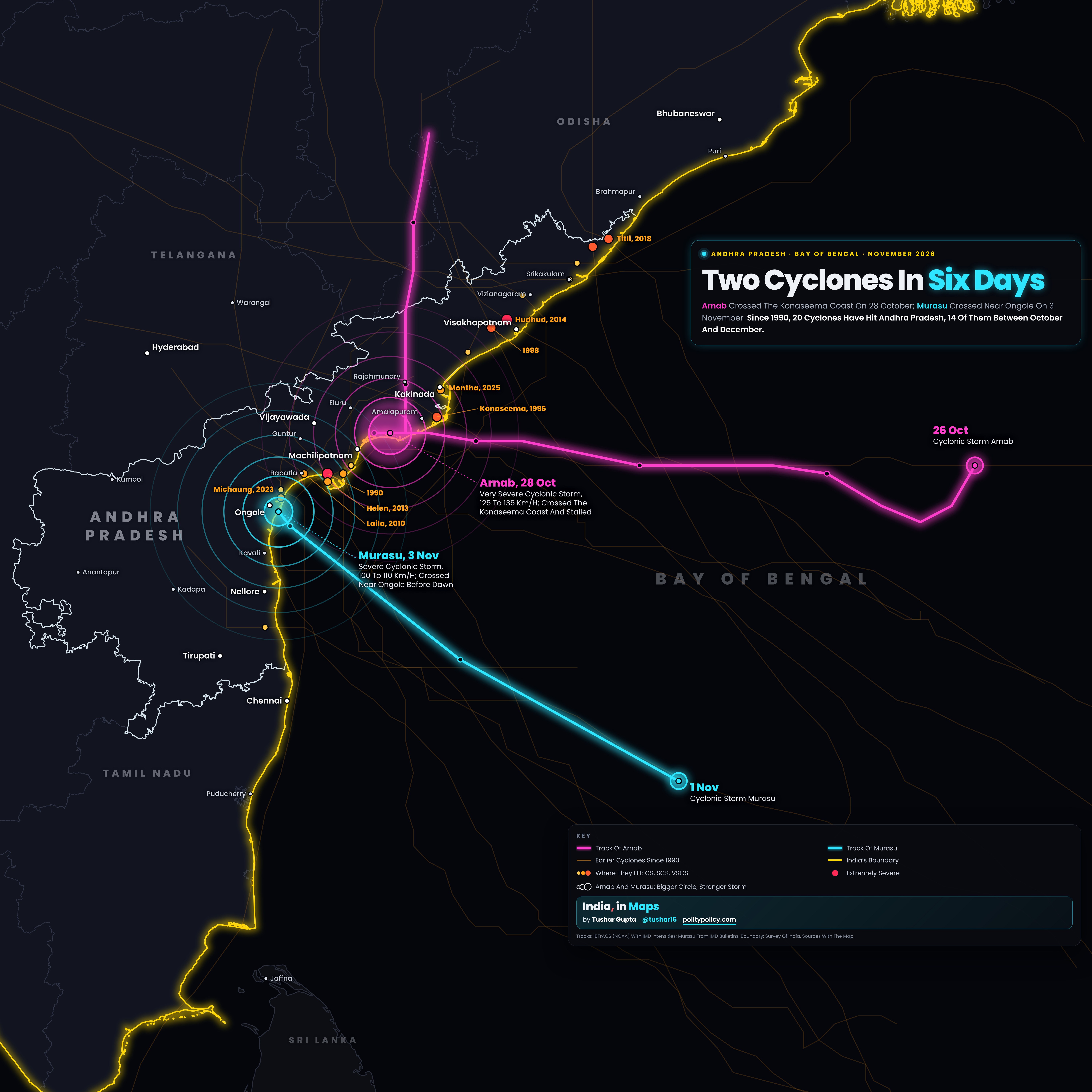
- The magenta line is Arnab’s track: it formed over the central Bay of Bengal on 26 October, ran west, crossed the Konaseema coast and stalled there before turning north into Odisha. Dots mark every 12 hours.
- The cyan line is Murasu’s track, from the India Meteorological Department’s bulletins: a cyclonic storm by 1 November, about 680 km east-south-east of Ongole, it crossed the coast near Ongole early on 3 November.
- The faint orange lines are the 17 earlier cyclones that hit the Andhra coast from 1990 to 2023; the dots show where each crossed, coloured and sized by its strength at the coast, from cyclonic storm to extremely severe cyclonic storm. Montha, of October 2025, is marked where it crossed.
- The glowing circles on Arnab and Murasu grow with strength, at the four points where IMD’s bulletins confirmed it: both were cyclonic storms when first named, Murasu reached the coast as a severe cyclonic storm and Arnab as a very severe one. Their full strength along the way will be added when IMD publishes its final tracks.
- The white outline is Andhra Pradesh. India’s boundary, in yellow, follows the coast.
Filter by month or by strength at the coast, and tap any storm to see its full track.
Arnab: It Stalled
Arnab formed over the central Bay of Bengal on 26 October and reached the Andhra coast as a very severe cyclonic storm, with winds of 125 to 135 km/h. On 28 October IMD described it as “practically stationary along the Andhra Pradesh coast” as it crossed over Konaseema. Kannuripalem in Anakapalli recorded 261.5 mm of rain; 609 schools became relief centres. The Chief Minister put the preliminary loss at ₹4,600 crore. In Odisha, floods and landslides that followed killed at least six people.
Murasu: Six Days Later
Murasu, a name given by India that means war drum, became a cyclonic storm on 1 November about 680 km east-south-east of Ongole and moved north-west at about 20 km/h. It crossed near Ongole in Prakasam district early on 3 November as a severe cyclonic storm, with winds of 100 to 110 km/h gusting to 120. IMD forecast a storm surge of 1 to 1.5 metres over Bapatla, Krishna and Prakasam. The state disaster management authority reported at least two deaths, 52,459 hectares of crops affected in 15 districts, 312 houses damaged, 2,750 electricity poles down and 12,230 people in cyclone shelters, and put the preliminary loss at at least ₹344 crore. Bapatla received 22 cm of rain in the 24 hours to 8:30 am on 3 November. More than 35 trains and several flights were cancelled; Odisha moved over 1.6 lakh people to safety.
A Year To The Day
Arnab crossed on 28 October, a year to the day after Cyclone Montha came ashore near Kakinada as a severe cyclonic storm with winds of 90 to 100 km/h. That makes three cyclones in twelve months, all crossing within about 280 km of one another.
Why October To December
Of the 20 cyclones that have hit Andhra Pradesh since 1990, 14 came between October and December, after the monsoon; the other six came between May and September. The strongest at the coast were the May 1990 cyclone near Bapatla, at about 165 km/h, and Hudhud, which hit Visakhapatnam in October 2014 at about 185 km/h. Before that record began, the November 1977 cyclone drove a seven-metre storm surge over Divi Seema in the Krishna delta; official estimates put the dead at over 10,000.
Each crossed the Andhra coast as a cyclonic storm or stronger, by the India Meteorological Department’s best-track data. Speeds are IMD’s three-minute sustained winds at the coast, rounded.
Sources And MethodShow
Tracks and intensities: IBTrACS version 4.01, NOAA National Centers for Environmental Information, North Indian Ocean file downloaded 3 November 2026, using the India Meteorological Department’s (RSMC New Delhi) best-track winds; Arnab’s track is the provisional one in that file. Murasu: IMD bulletins of 1, 2 and 3 November 2026 as reported by ANI, The Week and India TV; impact figures: Andhra Pradesh State Disaster Management Authority (Managing Director Prakhar Jain) via PTI, as reported by The Tribune and National Herald, 3 and 4 November 2026. Arnab: IMD bulletin of 28 October 2026 as reported by The Week; Andhra Pradesh State Disaster Management Authority via The Hans India, 28 October 2026; Chief Minister’s loss estimate via ANI, 1 November 2026; Odisha deaths via The Week, 2 November 2026. Montha: All India Radio (News On AIR), 28 October 2025. 1977 cyclone: Deccan Herald. Method: a cyclone is counted when its IMD best-track wind was at least 34 knots (cyclonic storm) within six hours of its centre crossing from the sea into Andhra Pradesh; categories use IMD’s scale. Map: Survey of India via DataMeet (boundary and states); Natural Earth (neighbours).