2012: The Siachen Pull-Back India Did Not Take
In September 2012 a group of retired Indian and Pakistani officers and diplomats, meeting in Lahore, agreed a plan for both armies to withdraw from Siachen. It was a Track 2 proposal, not a government one, and India never adopted it: the government insisted that the positions its troops held be recorded first, and the Army said Siachen’s strategic value had not changed. Fourteen years on, China has built a road into the Shaksgam Valley, the tract Pakistan illegally ceded to it in 1963, which lies directly north of the glacier, and China and Pakistan have held their first joint army exercise. The map shows what India kept. India’s boundary is shown as drawn by the Survey of India; PoK, Shaksgam and Aksai Chin are Indian territory under illegal occupation.
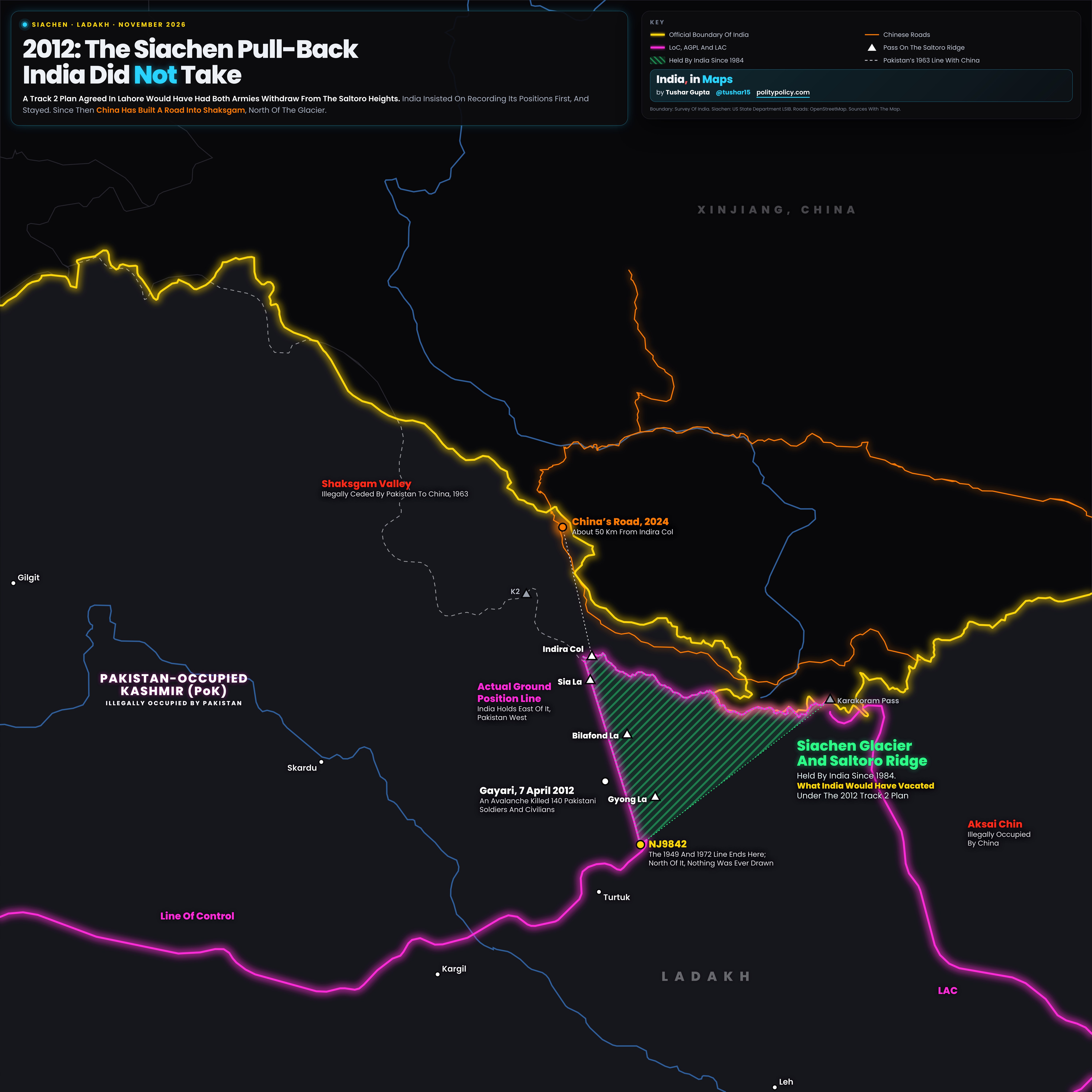
- The hatched green triangle is the Siachen Glacier and the Saltoro Ridge on its west, held by India since 1984: what India would have vacated under the 2012 plan. The white triangles are passes on the ridge: Indira Col, Sia La, Bilafond La and Gyong La.
- Two bright lines do the work. Yellow is India’s official boundary, as drawn by the Survey of India. Magenta is where the armies actually stand: the Line of Control up to NJ9842, then the Actual Ground Position Line along the Saltoro Ridge, with India east of it and Pakistan west, then the LAC with China.
- NJ9842 is where the line agreed in 1949 and confirmed in 1972 ends. North of it, the agreements said only that the line ran “thence north to the glaciers”.
- Between the two lines lie Pakistan-occupied Kashmir (PoK) and, under China’s illegal occupation, the Shaksgam Valley, ceded by Pakistan in 1963, and Aksai Chin. The dashed line is Pakistan’s 1963 line with China.
- Orange lines are Chinese roads. One crosses the Aghil Pass into Shaksgam and, by 2024, ended about 50 km from Indira Col, the northern tip of the glacier.
- Gayari is where an avalanche killed 140 Pakistani soldiers and civilians in April 2012, which set off that year’s talk of withdrawal.
What The 2012 Plan Said
Meeting in Lahore from 23 to 25 September 2012, retired Indian and Pakistani officers and diplomats in a Track 2 dialogue run with the University of Ottawa agreed “a proposal to demilitarize the Siachen area”. According to Vice Admiral (retd) Arun Kumar Singh, a member of the Indian side, both armies would withdraw from the conflict area, after jointly recording their present positions and exchanging the records; redeployment sites would be agreed jointly; and a joint commission would delineate the line beyond NJ9842. It was not a government proposal and was never adopted.
Why India Said No
India’s condition was that the positions its troops held be authenticated first. “We want authentication of the present positions,” Defence Minister A.K. Antony said in May 2012; “This is a pre-requisite before we can proceed further.” Pakistan wanted that record tucked into an appendix rather than marked on a map. The Defence Secretaries met in Rawalpindi in June 2012 without a breakthrough, and in September the Army Chief, General Bikram Singh, said the Army’s view of Siachen’s strategic value “has not changed at all”.
Why The Heights Matter
Since Operation Meghdoot on 13 April 1984 the Army has held the Siachen Glacier, and by 1987 it held all the commanding heights on the Saltoro Ridge, where Bilafond La alone sits at 17,880 ft. The ridge overlooks Gilgit-Baltistan to the west and the approaches to the Shaksgam Valley and the Karakoram Pass to the north. Giving it up, a former R&AW chief wrote in 2012, would mean its recapture would be extremely expensive in men and material.
What Has Changed: China In Shaksgam
The Shaksgam Valley, 5,180 sq km of Indian territory Pakistan illegally ceded to China in 1963, lies directly north of the glacier. By April 2024 a road from China’s G219 had crossed the Aghil Pass into the valley and ended about 50 km north of Indira Col; in January 2026 the Army noted a road roughly 30 to 50 km from the northern approaches to Siachen. India protested in May 2024 and again in January 2026, when the Ministry of External Affairs called the 1963 agreement “illegal and invalid” and the Army Chief said India does not approve of any activity in the valley.
China And Pakistan, Together
In October 2026 the Chinese and Pakistani armies held their first joint army training, Karakoram-2026, at Korla in Xinjiang, focused on counter-terrorism in high-altitude areas, with Pakistani troops on Chinese equipment. A withdrawal in 2012 would have left India relying on Pakistan’s word alone, on a front where China is now building to the north.
The Kargil Lesson
In 1999 Pakistani troops crossed the Line of Control at Kargil, south of Siachen, and dug in on heights in the gaps between Indian winter posts; the Kargil Review Committee found they had occupied one post India had vacated. Clearing them took a war. Critics of the 2012 plan argued that a withdrawn Saltoro Ridge could be reoccupied the same way, and retaken only at great cost.
The Case For Leaving, And Its Cost
The plan’s backers had a case. 869 Indian soldiers died in Siachen from 1984 to 2015, most to weather and terrain rather than fire; holding it cost an estimated Rs 2 to 3.5 crore a day in 2012, and the glacier is littered with waste. Gurmeet Kanwal, a former head of the Army’s think tank, called demilitarisation “a low-risk option to test Pakistan’s long-term intentions”. Fourteen years on, with China in Shaksgam, the risk looks larger than it did.
Sources And MethodShow
2012 proposal: University of Ottawa media release, 3 October 2012; Vice Admiral (retd) Arun Kumar Singh, a member of the Indian delegation, in the Deccan Chronicle, reprinted by the Atlantic Council, 9 October 2012; Sunday Guardian, 1 November 2026. Government positions: A.K. Antony, as reported by The Tribune, 9 May 2012; joint statement, Defence Secretary talks, Rawalpindi, 11-12 June 2012 (Pakistan Ministry of Foreign Affairs); General Bikram Singh, as reported by Business Standard, 20 September 2012. Gayari: ISPR, as reported by Geo, 2 May 2018. General Kayani: VOA, 18 April 2012. Operation Meghdoot and Bilafond La: The Tribune, 13 April 2025; USI of India, April 2024. Karachi Agreement, 1949 (SATP). Deaths: Lok Sabha data, as reported by IndiaSpend in Business Standard, 12 February 2016; A.K. Antony, Lok Sabha, 28 August 2012. Shaksgam: Lok Sabha, 4 February 2022 (5,180 sq km); India Today, April 2024, via Claude Arpi, Shiv Nadar University (road about 50 km from Indira Col); The Tribune, 10 January 2026; Ministry of External Affairs, 2 May 2024 and January 2026; All India Radio, 13 January 2026 (Army Chief). Karakoram-2026: Observer Research Foundation, 29 October 2026; Global Times, 14 October 2026. Kargil: Kargil Review Committee report. Counter-arguments: Gurmeet Kanwal, Atlantic Council, 17 April 2012; Vikram Sood, ORF, 16 April 2012. Map: Survey of India via DataMeet (boundary); US State Department LSIB (Siachen); Natural Earth (PoK, Shaksgam, Aksai Chin, neighbours); OpenStreetMap contributors, ODbL (roads, passes).