Shaksgam: The Indian Valley Pakistan Illegally Ceded To China
In 1963 Pakistan illegally ceded 5,180 sq km of Indian territory in Pakistan-occupied Kashmir (PoK), the Shaksgam Valley, to China under the so-called China-Pakistan boundary agreement, which India has never recognised. On 16 and 17 September 2026 the two countries held the first meeting of a so-called joint commission to manage that line; India rejected it, saying there is no boundary between Pakistan and China. As India has always maintained, the entire Union Territories of Jammu and Kashmir and Ladakh, including PoK, Shaksgam and Aksai Chin, are an integral and inalienable part of India. The map shows India’s boundary as drawn by the Survey of India, Pakistan-occupied Kashmir (PoK) and Aksai Chin, both Indian territory under illegal occupation, the 1963 line, and what China has built since.
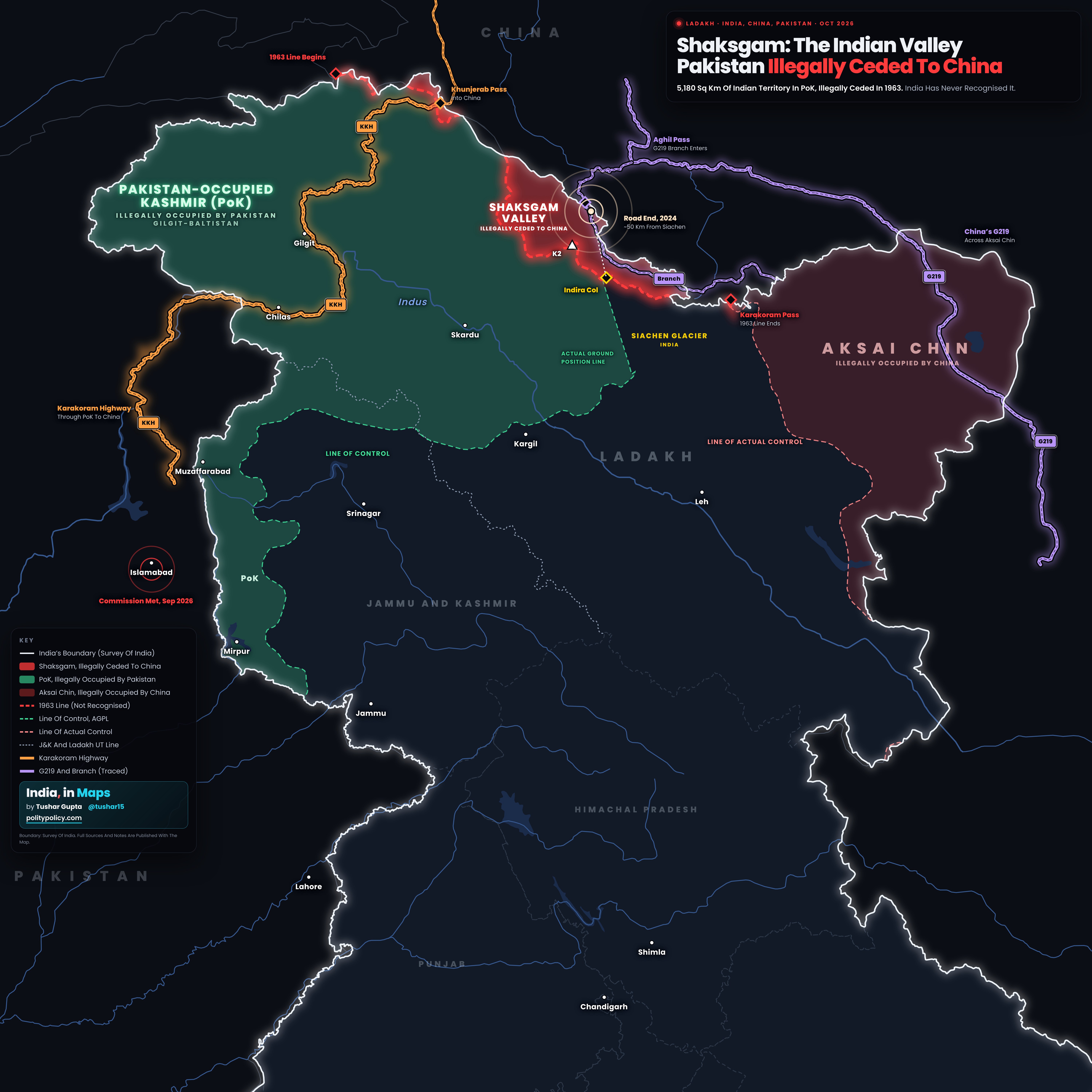
- India’s boundary is drawn as published by the Survey of India. Everything inside it is Indian territory; the shading marks the parts under illegal occupation.
- Red is the Shaksgam tract that Pakistan illegally ceded to China in 1963. Light red is Aksai Chin, under China’s illegal occupation. Green is Pakistan-occupied Kashmir (PoK), including Gilgit-Baltistan, under Pakistan’s illegal occupation. The Siachen Glacier, where the Indian Army has been deployed since 1984, is unshaded like the rest of India; the green dashed line to its west is the Actual Ground Position Line, drawn approximately.
- The red dashed line is the 1963 China-Pakistan line, which India does not recognise. The green and pink dashed lines are the Line of Control and the Line of Actual Control.
- Roads are drawn with a dark edge and a dashed centre line, so they do not read as boundaries. Orange is the Karakoram Highway, Pakistan’s road to China, which runs through PoK to the Khunjerab Pass. Violet is China’s G219 highway, which crosses Aksai Chin from Xinjiang to Tibet, and its branch over the Aghil Pass into Shaksgam. The branch is traced from satellite images by OpenStreetMap contributors (who tag it G695) and is not independently verified. The ring marks where India Today reported the road ended in April 2024. The two highways connect only inside Xinjiang, north of the map.
- India’s boundary is the Survey of India’s. The extent of the occupied areas is approximate, drawn from open line datasets listed in the sources; the areas quoted are the Government of India’s figures.
Where Three Armies Meet
Near Indira Col, India’s Siachen Glacier meets two areas under illegal occupation: the tract Pakistan illegally ceded to China, and PoK. The ceded valley lies directly north of the glacier, where the Indian Army has been deployed since April 1984.
A Way Across The Aghil
India’s boundary here runs along the Aghil range, the frontier with Xinjiang before 1947. China’s road now crosses the Aghil Pass from its G219 highway into the valley.
A Road Edging Towards Siachen
India Today reported in April 2024 that the road reached about 50 km north of Indira Col. India protested in May 2024. In January 2026 the Army Chief called the 1963 agreement illegal and said India does not approve of any activity in the valley.
A Provisional Line, Now With A Commission
Even the 1963 agreement treats its line as provisional. Article VI says that after “the settlement of the Kashmir dispute between Pakistan and India”, the sovereign authority concerned will reopen negotiations with China. India rejects the agreement as illegal and invalid. The so-called commission now deals with surveys, markers and crossings on that same line.
CPEC Runs Through PoK
About 400 km of the Karakoram Highway runs through Pakistan-occupied Kashmir (PoK), Indian territory under Pakistan’s illegal occupation, to the Khunjerab Pass. China’s Exim Bank lent $327.74 million to rebuild its 335 km Raikot to Khunjerab stretch. India does not recognise the so-called China-Pakistan Economic Corridor.
What India Says
The entire Union Territories of Jammu and Kashmir and Ladakh, including PoK, Shaksgam and Aksai Chin, are an integral and inalienable part of India. On 16 September 2026 the Ministry of External Affairs said, “There is no boundary between Pakistan and China,” called the so-called joint commission “without any legal basis”, and asked Pakistan to vacate the areas under its illegal and forcible occupation.
Beijing’s Claim, Which India Rejects
On 12 January 2026 China’s foreign ministry claimed the valley as “part of China’s territory” and called its construction there “beyond reproach”. The claim rests on the 1963 agreement, which India has never recognised. India has repeatedly protested against Chinese attempts to alter the ground reality in the valley.
The Karakoram Highway is Pakistan’s road to China and runs through PoK. China’s G219 never enters Pakistan; it crosses Aksai Chin. The two connect only inside Xinjiang, north of the map. The road into Shaksgam is a branch of G219.
Pakistan’s Foreign Office says its so-called Boundary Joint Commission with China, set up under a 2013 China-Pakistan agreement, will handle the following, in its own words. India rejects the commission as without any legal basis. The first meeting, in Islamabad on 16 and 17 September 2026, also discussed the movement of goods and people. The next will be held in China.
Sources And MethodShow
Ministry of External Affairs: weekly briefings of 2 May 2024 and 9 and 16 January 2026, and statement of 16 September 2026 (as reported by ANI and The Tribune); External Publicity Division, “Sino-Pakistan Agreement: Some Facts”, 16 March 1963. PIB: Raksha Mantri’s statement in the Rajya Sabha, 17 September 2020 (38,000 sq km; 5,180 sq km); Operation Meghdoot, 13 April 2024. Lok Sabha, written reply of the External Affairs Minister, December 2018 (78,000 sq km), as reported by ThePrint. Text of the 2 March 1963 agreement (Article VI) and US State Department, International Boundary Study No. 85 (1968) for the 1965 protocol and the 40 pillars. Pakistan Foreign Office on the Boundary Joint Commission, via Express Tribune, 18 September 2026. China’s foreign ministry, 12 January 2026, via Deccan Herald. India Today OSINT, 25 April 2024, via Raksha Anirveda and Shiv Nadar University’s Centre of Excellence for Himalayan Studies (Claude Arpi, also for the Aghil range as the pre-1947 frontier). Army Chief General Upendra Dwivedi, press conference of 13 January 2026, via All India Radio (News On AIR). G695 in China’s 2022 national highway plan: PTI citing the South China Morning Post, 20 July 2022. Karakoram Highway loan: AidData. Boundary: Survey of India via DataMeet; UT line from the Survey of India map of 2 November 2019 via DataMeet. Illegally occupied areas: Natural Earth and US State Department LSIB (Siachen), approximate. Karakoram Highway, G219 and the road into Shaksgam: OpenStreetMap contributors (ODbL), fetched 27 October 2026; the Aghil Pass is marked where that road crosses India’s boundary. Road-end distance and Karakoram Highway length are straight-line and map measures.